OUR BLOG

Featuring marketing tips, tech news, digital wonders, some personal things and everything in between . . .

Geocaching How to Safely Place A Geocache


Sunday May 31, 2009

Reading Time: 3 minutes

Guidelines That Apply to Placing All Cache Types,

For all physical geocaches and waypoints, think carefully about how your container and the actions of iPhone geocachers will be perceived by the public. For example, a cache hidden in full view of a restaurant or apartment building window exposes the geocacher to being seen by someone who may think the cache search looks suspicious. Your cache may be hidden on public property but there may be concerned residents on the other side of that property line. And, while an ammo box or PVC pipe may be a great container if hidden deep in the woods, it may cause alarm if discovered in an urban setting. A clear plastic container or a microcache may be a better choice. In busy areas, avoid containers that look suspicious, including attachment materials like wires or tape. To reduce confusion and alarm when a cache is discovered accidentally, clearly label your container on the outside with appropriate information to say it is a geocache. Cover over any military markings with paint or a geocache sticker. Include an explanatory “stash note” inside your cache. Common sense in selecting hiding spots and containers can reduce the risk of your cache being perceived as a danger to those who are unaware of our sport. For more on Geocaching and how to place a geocache please visit Geocaching.com

Reading Time: 3 minutes


iPhone Geocaching with

Groundspeak’s Geocaching iPhone Application


Geocaching is a global treasure hunting game where participants locate hidden containers, called geocaches, outdoors using GPS enabled devices and then share their experience online at http://www.geocaching.com/
iPhone Geocaching puts this sport in your pocket!
Groundspeak’s Geocaching iPhone Application Features:
  • Direct access to Geocaching.com’s database of worldwide geocaches
  • Search by current location, address or lookup code
  • Access geocache details, including description, hint and recent logs
  • Save geocache listing for quick retrieval
  • Log geocache finds and post notes in the field
  • Filter your hides and finds from the Geocaching.com search results
  • Navigate to geocaches with a simulated compass arrow
  • Look up trackable item detail, including item goals, while on the trail
  • NEW Tweet your new iPhone Geocache finds thru Twitter!
The Geocaching iPhone Application is available in Dutch, French German and Japanese language versions. Groundspeak’s Geocaching Application is best supported by the iPhone 3G but it is also compatible with the iPod Touch and 1st generation iPhones. (USE THE FORCE LUKE!)
Please note: You will need Wi-Fi access for the application to work on the iPod Touch. Also, without GPS, compass navigation will not work on the 1st generation iPhone.

iPhone Geocaching How it works

The iPhone 3G uses a combination of GPS, Wi-Fi positioning and cell towers to determine your approximate location. Groundspeak’s iPhone Application then queries the Geocaching.com database in real-time and provides a list of geocaches near you. The application can also geocode addresses, search using a location from your address book, or look up a geocache or trackable item by it’s GC (Geocaching.com) code.


Ready to go iPhone Geocaching?
Hit the iTunes Store to download Groundspeak’s Geocaching iPhone Application now!


Reading Time: 4 minutes

This Sunday Lisa and I met up with Jshults to do a little iPhone geocaching. The first cache we found was the San Onofre Breccia – Dana Point Earthcache (http://coord.info/GCP80W) to “complete” this cache we should have also gone to see the other half of the San Onofre Breccia that is exposed at Aliso Point (http://coord.info/GCP805) Just south of the San Onofre Nuclear power plant.

This is the Photosynth I took of the exposed cliffs of Dana Point a section of the San Onofre Breccia, a 15 to 20 million year old formation. A breccia is a sedimentary rock composed of angular fragments (clasts) embedded in a fine-grained matrix (the ‘glue’ that binds the clasts together). In the San Onofre Breccia, the clasts range in size from less than an inch to the size of small trucks and are a variety of rock types, mostly metamorphic. A formation is a rock that can be easily recognized over a large area.

From here we walked along the beach and tide pools (no dogs allowed) to the very tip of Dana Point and our primary target for the day the Sea Caves Geocache (http://coord.info/GC1KBVM) Photo by Lisa McClure, After searching where we thought the cache should be and thinking it may have been either washed out to sea, been muggled, or perhaps fallen too far down the rabbit hole for retrieval. We were pleased to be greeted by the owner of the cache “Masoe”. “Yep thats where it was, Nope it is not there anymore.” Jshults being the seasoned cacher that he is retrieved a pre camo’d altoids tin sealed the rabbit hole and replaced the new cache, (After giving us time to sign the log book! TNLNSL! TFTC!)

The people we have met while out and about on our caching adventures have been truly interesting, and give you a great reason to get out in the world. We also notice that geocaching gives us a unique spacial awareness of a place that we did not have before, given that in looking for a cache you are focused on a space the size of your living room. Once the cache is found that moment and that space are etched into your internal map of the place.

All who wander are not lost, Some of us are out iPhone Geocaching! Wanna go?

Reading Time: 11 minutes
national geographic magazine
National Geographic Feb 2009

The February 2009 edition of National Geographic arrived this week. There on the cover were two magical words “Mount Washington”. Mount Washington(6,288 ft), the highest peak in the northeastern United States, is located in the Presidential Range of the White Mountains of New Hampshire. What makes this article, Backyard Arctic, all the more interesting to me is that for 12 years I lived within 20 miles of this magical peak. Over those years each member of my immediate family had their own experience with the mountain. There are many ways of traversing Mount Washington and we lived to tell about it.

If you have never heard of Mount Washington you might be quick to ask: “What do you mean you lived to tell about it, Mount Washington only has an elevation of 6,288 ft?” I, too, was skeptical when I first arrived in New Hampshire in 1985. After all I had lived most of my life in Southern California where a 6,288 ft peak might be considered a foothill. As a young adult I had backpacked to the top of Mount San Gorgonia (11,499 ft) and San Jacinto Peak (10,834 ft). I had lived in Alaska and toured Denali National Park to witness Mount McKinley (20,320 ft), but after living in New Hampshire for a very short time I learned that Mount Washington is “Home to the World’s Worst Weather”, holding the all-time surface wind speed record of 231 mph (April 12, 1934). And sadly, Mount Washington is one of the 10 deadliest mountains in the world!

Perhaps what makes this jewel of the White Mountains so deadly is its accessibility and unfortunately not everyone who visits is prepared for the fact that the weather can turn quickly. You do not have to be a hiker, backpacker, proficient ice-climber, or skier to enjoy this mountain. Since 1861 people have been driving up the Mount Washington Auto Road, the oldest man made attraction in America. Not interested in driving up the mountain? Then you can ride to the top on the Cog Railway which has been carrying passengers since 1869. If you are really adventurous, then in the Spring you can hike up the mountain with your skis on your back and ski down the bowl, Tuckerman’s Ravine.

And if all this is not enough to capture your imagination there are races to the top of Mount Washington. The Climb to the Clouds, an auto race, was held in 1904 and continues to this day. There is the Mount Washington Auto Road Bicycle Hill Climb, a tradition for the past 36 years; the Ride to the Sky for motorcyclists; for runners there is the Mount Washington Road Race, and most years there is the Nordic Ski to the Clouds Race (North America’s Toughest 10K).

I started this post by saying each member of my family had been to the top of the mountain and lived to tell about it. Since they are a little reticent to share their feats with you, I will. Enjoy today’s photos from the family scrapbook…

mount washington
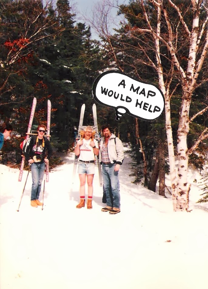
Dennis Helfand (right) hiking up Mt. Washington, Circa 1989

Around 1989 Dennis hiked up Mount Washington with a number of our guests from Cranmore Mountain Lodge. It was a Spring day and they were going to ski Tuckerman’s Ravine. While Dennis opted out of the ski run, he did hike up and down the mountain that day.


aaron helfand
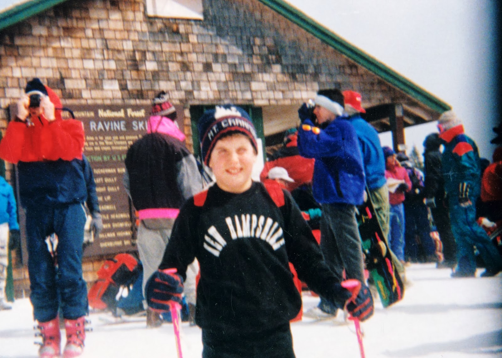
Aaron Helfand Tuckerman’s Ravine, Circa 1992

I believe it was 1992 when Dennis convinced Aaron(who was about 11 at the time)to hike up the mountain with another group of guests. Not only did Aaron hike up the mountain, but being a proficient downhill ski racer, he skied the bowl.


daniel helfand
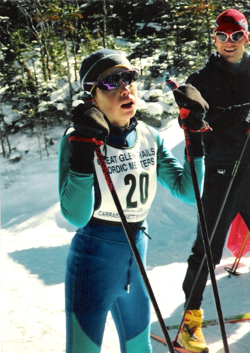
Daniel Helfand at the finish line 1996 Ski to the Clouds, Tom Thurston, his coach looking on

In 1996, Daniel, a ski racer from the age of four, was the youngest competitor in the inaugural nordic Ski to the Clouds Race. He was 12! Not only was he the youngest to compete, but he finished the race.

At this point you are probably wondering how I traversed Mount Washington. Take a guess? You are correct…in a Mt. Washington Auto Road Stage Line Van driven by a tour guide. I was taking no chances. I had to live to tell about it. Today the Mount Washington Auto Road also offers the SnowCoach, weather permitting.

There is so much to learn about Mount Washington and so many ways to do it. Until you have a chance to experience it for yourself, I invite you to visit the sites referenced here today. One of my favorites is The Mount Washington Observatory. The history and majesty of this mountain will intrigue you. But you will learn that while man’s ingenuity continues to try to tame and groom this mountain, it remains a force of nature that we can and must respect.

I would like to thank Howie Wemyss, a trustee for the Observatory. This week I contacted Howie at Great Glen Trails to ask if the records still existed regarding the 1996 Ski to the Clouds Race. Howie was nice enough to write me back: “I remember the race very well and how impressed we all were with your son…but unfortunately all of the records were destroyed in a fire in 2001.” At Howie’s suggestion I contacted Tom Thurston, Daniel’s fifth grade teacher and X-Country ski coach. Tom, too, has fond memories of this race: “I remember that day on the toll road when he (Dan) skied the Ski to the Clouds. He was so tired but loved the ski back down.”

As I sign off today I would like you to know that the current conditions on Mount Washington (9:45 AM EST 01/24/2009) are:
Temperature -7.6 degrees F
Wind 71.7 mph
Direction 298 degrees (NW)
Gust 76.0 mph
Wind Chill -46.2 degress F

A great spot for Geocaching!
If you have been to Mount Washington, let me know about your experience.

Reading Time: 2 minutes

What do we do for fun when not building websites? We like to go GEOCACHING! What is geocaching you might say? (You must be a muggle!) Geocaching is people just like you, using a billion dollar satellite system to find hidden tupperware! But seriously folks, geocaching is a huge world wide phenomenon, with equal measures of search and explore built right it. Maryland recently started a state wide geocaching trail to help drive tourism. The next day an NBC reporter contacted me thru Twitter to ask me about it. ( I have been tweeting my finds and caches ) and I gave him this info.

There are 708,619 active caches worldwide.
In the last 7 days, there have been 688,000 new logs written
by 77,717 account holders.

Geocaching is fun sport that can be enjoyed where ever you may find yourself. Go to Geocaching.com, sign up for a free account, and do a search for caches in your zip code.

Remember, All who wander are not lost, some are geocachers.

HAPPY HUNTING!

Let's Go iPhone Geocaching with the McClures

Reading Time: 7 minutes

What do you know about geocaching? I know very little, but have you ever thought about why we have odd and even house numbers? I have to admit I don’t spend a lot of time thinking about this concept, but the other evening I happened to be watching the History Channel about Napoleon and the commentator mentioned that it was Napoleon that came up with the idea of odd numbers on one side of a street and even numbers on the opposite side of the street. No big deal, you might say. But think about how this simple idea impacts your daily life: mail delivery, GPS, visitors, emergency support…the list goes on. OMG, could Napoleon be the father of Geocaching?

I am not going to bore you with a whole history of street numbering, but it occurred to me that I have lived long enough to remember life before Zip Codes (pre 1963) and I have lived in enough different communities to know how challenging life can be when you don’t have a numbering system. In today’s world this is akin to not having order in the World Wide Web. Order is what makes the Internet work and allows all of us to stay in touch.

The first time I learned about life with mail delivery placed in a road side box was in Anchorage, AK. It was 1983 and we were transferred to Alaska. Our house address was 15040 Platinum Circle; however, our mailing address was SRA (Star Route Assignment)Box 460, Anchorage, AK 99507. Just when I had all of our friends trained to send mail to the SRA address, the USPS decided that we had to start using our actual street address for mail. Hmmmm…wouldn’t you know that was the year that I was president of the home owners association and we had to build a whole new series of postal boxes which needed to be identical in every way, clearly marked with our street addresses (as opposed to the SRA addresses), and all 20 boxes had to be attached to a sturdy metal pole system. (Thank god a number of the neighbors were engineers that worked on the North Slope – read not Dennis).

In late 1985 we moved to Conway, New Hampshire. Now one would think that since New Hampshire was one of the 13 original colonies, street numbers would be old hat. WRONG! 90% of the homes and businesses did not have street numbers, for that matter, most roads were not clearly marked or had many different names for the same road. For example, Main Street in Conway Village was also known as RT16/RT113. I worked for Indian Head Bank North which was located on Main Street. Vendors would ask me for my business address and I would simply say “Indian Head Bank North, Main St, Conway, NH 03818”. The vendor would repeatedly say what is the street number and I would simply say “we don’t have street numbers!”

By late 1986 we purchased our country inn on Kearsarge Rd, Village of Kearsarge, Town of Conway, Carroll County, New Hampshire. We did not have a street number. Our mail went to P O Box 1194, North Conway, NH 03860 (only because for marketing purposes more people recognized North Conway, as opposed to Kearsarge Village, which had its own zip code, 03847). Are you confused yet? In late 1996 Conway Town Officials decided we all needed to put street numbers on our homes and businesses, because if we were to dial 911 the fire, rescue and police needed to know how to find us. You don’t want to know how many properties burned to the ground in the old days when buildings had no addresses and we depended on volunteer fire departments. So in 1996, Cranmore Mountain Lodge received its street number: 859 Kearsarge Rd, Kearsarge, NH 03847. 175 years after Napoleon’s death(1821)!

So today when you are searching for an address using the Internet, your GPS navigation system, your iPhone, or GeoCaching…thank Napoleon for being so practical. For fun here is a YouTube video called Geocaching Napoleon. I have no idea what it is about, because I don’t speak French, but maybe it is fitting.

Reading Time: 3 minutes

Google released its Google Earth browser for the iPhone and its FREE!!!

What is Google Earth? And if you are an iPhone Geocacher why do you want this is Free App? Watch the above video from Google to find out, In short, Google Earth for the iPhone is Google Maps in 3D, and with just a flip of a switch in the apps settings you can turn on the Latitude and Longitude of your location, very important information for us iPhone Geocaching folks!

With a quick trip to Geocaching.com to find the latitude and longitude of the caches you will be hunting for, make note of that info for later reference. Match up your location, with the location on your note and then start the drunken bee dance in search of your prize!

Google Earth for the iPhone provides most of the functionality of the full program but formatted to fit your iPhone. Pressing the “My Location” button in the lower left of the iPhone display and your perspective changes from one of viewing planet earth right down to seeing what car was parked in your driveway at the time the satellite photo was taken. Impressive, detailed sat shots and you have the option of viewing these as maps or the live terrain or a hybrid of both.

Search functions for Google Earth are also included. Search for addresses, specific businesses, landmarks in relation to where you are on earth. Those of you familiar with Google Earth will also love the addition of the Wikipedia and Panoramio layers.

Google Earth for iPhone, Yet another cool tool in the iPhone Geocachers Tool kit.

Click here to open iTunes and download the Free Google Earth iPhone Geocaching App.

Reading Time: 3 minutes

iPhone Geocaching Profile for Darin R McClure

Happy Columbus Day, Get outside and find something!

iPhone Geocaching the outdoor treasure-hunting game in which we participants use the GPS receiver built into our 3G iPhones to hide and seek geocaches. There is a hidden world all around us, with treasure, trinkets, coins and bugs to find.

Step #1 Visit the iTunes app store and grab Groundspeaks New iPhone Geocaching Application,

Step #2 Head over to Groundspeaks website, Geocaching.com and sign up for a free account,
( not required to use the app, but join up to keep track of your finds, and meet folks)

Step #3 Crank up your iPhone Geocaching App, and find a cache! don’t let the Muggles catch you!

Step #4 Take a shot of the area & the cache contents with your iPhone, making sure not to give away the location of the hide.

Step #5 Go back to Geocaching.com and log your visit & share your photos, and if you found or did not find the cache.

With hundreds of thousands of caches hidden around the world you are sure to find one nearby. Being that you always have your iPhone with you, next when you find yourself with some extra time on your hands instead of plopping down in from of the television, take your family on a hunt for treasure.

iPhone Geocaching, Where you are the search engine.

Reading Time: < 1 minute

Watch Steve Jobs unveil the new iPhone 3G, Apple’s new App Store, MobileMe, and more in the 2008 Worldwide Developers Conference keynote address from San Francisco’s Moscone West.